Rambling in Seefeld. Walking Routes in Spring
- Raúl Revuelta
- Apr 23, 2024
- 3 min read
Updated: Apr 29, 2024
The Region Seefeld with its villages of Mösern, Scharnitz, Reith, Leutasch, and Seefeld, is nestled on a south-facing high plateau at 1,200 m, surrounded by the Karwendel Nature Park.
Seefeld is an old farming village located between the Wetterstein mountains and the Karwendel, in the Innsbruck-Land District in the Austrian state of Tirol. The Wildsee, also called the Seefelder See ("Lake Seefeld"), gave the village its name.
With its incredible variety of sports, leisure activities, and experiences, Tirol's high plateau is a real favorite place for 365 days.
Seefeld is the “postcard pretty” Austria that you have in your mind. A simply breathtaking variety of nature stretches between the peaks: all in all, there are over 1,000,000,000m² of unspoiled Alpine landscapes, cool forests and lush meadows, thunderous waterfalls, and crystal-clear mountain lakes to discover in the Seefeld Region.
At an altitude of 1,200 meters, you are already starting your walking day in the heart of the mountains rather than down in the valley.
Seefeld is a winter wonderland for ramblers, with 650 km of hiking trails where you can also enjoy easy hikes and walks.
The Region Seefeld is a proud member of the Austrian Hiking Villages, which specialize in hiking and nature-based tourism.
The Austrian Hiking Quality Seal captures the “magic of walking” in its entirety. The interaction of the village, as a hiking starting point in nature, specialized hiking hosts, and the path that captures the beauty of the landscape are essential for the perfect hiking experience.
The following two trails has been awarded by the Austrian Hiking Seal of Quality in the category 'Hiking Trails" and are easy paths to discover the beauty of the Seefeld Region from Spring (from april onwards) to Autumn (October).

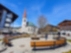
This one-hour easy walk begins at the information office in Seefeld close to the train station (1180 m). It leads through the pedestrian zone to the late Gothic parish church of St. Oswald and further up to the parish hill. Here, at 1203 meters, you will find the Circle of Apostles or Seefeld Way of the Cross, built in 2000, with 14 stations. With the help of boulders weighing up to 23 tons, which are placed in a certain constellation of stars, the Last Supper is represented here. According to an idea of the writer Winfried Werner Linde, this strong place at the highest point of the parish hill should represent a peaceful meeting point for people of all world religions.

From Pfarrhügel you walk to Seefelder Wildsee and through the Reither Moor, where you will find information on various topics on eleven boards. The walk ends back in the pedestrian zone at the Seefeld information office.
In a small settlement next to Lake Wildsee, between Reith and Seefeld, known as "Sevelt" ("lakeside field") documented in 1022, lies the origin of the city of Seefeld.
Emperor Maximilian I used it for fish farming and had lampreys introduced, which is why the lake also bore the name Lampretensee.
Today, the Wildsee is a popular bathing lake with two beaches.

Tip: From May 1, the Strandperle Café-Restaurant, located next to the lake, is a must-see.
In summer, at the "Beach Pearl" swimmers can swim in the lake and the heated outdoor pool, while the little ones can enjoy the paddling pool and playground. You can also enjoy a wide variety of activities such as beach volleyball, water trampoline, pedal boats, kayaks, stand-up paddleboarding (SUP), and yoga courses.
The bathing beach by Waldbad Sonja on the other hand, is a little quieter and is the perfect spot if you are simply looking to relax.


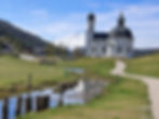
This three-hour trail starts from the baroque church of Seekirchl (1179 m), the most famous landmark and probably the most popular photo motif in the region of Seefeld. From there follow the signs towards Brunschkopf/Wildmoosalm. You walk past the World Cup hall and through the Kirchwald residential area. After changing to path no. 2, follow the forest path uphill and turn left towards Möserer See. Continue on forest path no. 60 to the Geiernest junction. There turn right onto path no. 63 to Brunschkopf.
The last few meters branch off steeply to the left (route no. 62 signposted for Brunschkopf) and take you up some steps to the Brunschkopf viewing platform (1493 m.), the "sky cinema". The mountain panorama is fabulous and is best appreciated through the top-quality lens of the Swarovski telescope which you will find there.
The descent follows the same path until you reach the junction towards Wildmoosalm. From there follow the signs towards Seefeld and then turn onto Hörmannsweg. Through the Kirchwaldsiedlung you get back to the starting point at the Seekirchl.

For a cozy end to the day, Seefeld rewards you with many beautiful cafés, bars, restaurants, and sun terraces.